
Blitz Bureau
NEW DELHI: Digital maps and spatial intelligence are reshaping how highways are envisioned and built. Behind this change is the powerful synergy between Geographic Information System (GIS) and the Government’s flagship initiative, PM Gati Shakti National Master Plan (NMP).
Fast becoming the digital command centre for infrastructure development in India, especially for highways, the NMP portal acts as a comprehensive digital atlas for integrated, multimodal connectivity. At its core is a powerful GIS-based platform that hosts over 550 layers of live data, including economic clusters, logistics hubs, social infrastructure, environmental features, and more.
In a major milestone, the Ministry of Road Transport and Highways has uploaded and validated the entire National Highway network (about 1.46 lakh km) onto the GIS-based NMP portal. This marks a crucial shift in how the country’s highways are planned and executed.
Intelligent transport
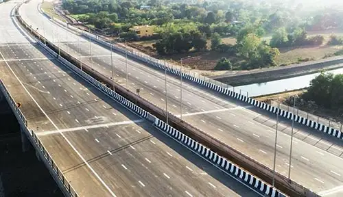
When we talk about tech powered corridors, the pavement is only half the story. The other half lies in systems that sense, analyse, enforce, and react, collectively known as Intelligent Transport System (ITS).
ITS is being implemented primarily through Advanced Traffic Management System (ATMS) and is gradually being integrated into a broader Vehicle-to-Everything (V2X) communication ecosystem. These systems are designed to significantly reduce road accidents, minimise traffic violations, and accelerate emergency response times.
ATMS has been deployed on major expressways like the Delhi–Meerut Expressway, Trans-Haryana Expressway, and the Eastern Peripheral Expressway, enabling faster incident detection and quicker response times. Importantly, ATMS installation is now a default component in new high-speed NH projects and is also being adapted as standalone systems on key existing corridors.
The Government is enhancing highway transparency and safety with smart technologies rolling out project information sign boards featuring QR codes for real-time project details, emergency helplines, and nearby amenities. Network Survey Vehicles (NSVs), equipped with 3D laser systems and 360° cameras, etc. will be deployed across 23 states to automatically detect road defects.
Green miles ahead
India’s commitment to sustainable infrastructure is also reflected in the Green Highways Mission, launched under the Green Highways (Plantation, Transplantation, Beautification and Maintenance) Policy, 2015. Its objectives include minimising pollution and noise, preventing soil erosion, and generating employment opportunities.
In 2023–24, the National Highways Authority of India (NHAI) planted over 56 lakh saplings, followed by another 67.47 lakh in 2024–25. Together, these efforts have taken the total count of trees planted along national highways to over 4.69 crore since the mission’s inception, but the green transformation doesn’t stop at plantations.
The NHAI has also focused on reviving water bodies along highways. Under Mission Amrit Sarovar, launched in April 2022 with a view to conserve water for the future, it has developed 467 water bodies across the country.
Engines of change
India’s highways are evolving from engines of transport into engines of transformation. What began as a mission to connect cities has grown into an ambitious effort to connect systems, linking people, data, and decisions through a web of smart, sustainable, and digitally empowered infrastructure.
The integration of GIS-driven planning, intelligent traffic systems, digital tolling, and citizen-centric apps has turned the highway network into a structure that senses, responds, and learns in real time. Each expressway now doubles as a channel of connectivity and a node of national intelligence, ensuring that mobility in India is not just faster, but safer, cleaner, and more transparent.


